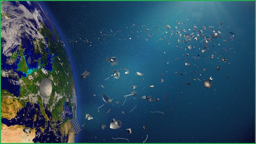
Project Netra
Context:
With space junk posing increasing threat to Indian assets in space, the Indian Space Research Organisation (ISRO) is building up its orbital debris tracking capability by deploying new radars and optical telescopes under the Network for Space Objects Tracking and Analysis (NETRA) project.
Relevance:
GS III- Science and Technology
Dimensions of the Article:
- What is Project NETRA (Network for space object Tracking and Analysis)?
- Significance of the project
- What is Space Debris?
What is Project NETRA (Network for space object Tracking and Analysis)?
- Under the project, the ISRO plans to put up many observational facilities: connected radars, telescopes; data processing units and a control centre.
- They can, among others, spot, track and catalogue objects as small as 10 cm, up to a range of 3,400 km and equal to a space orbit of around 2,000 km.
Significance of the project:
- The project will give India its own capability in space situational awareness (SSA) like the other space powers — which is used to ‘predict’ threats from debris to Indian satellites.
- NETRA’s eventual goal is to capture the GEO, or geostationary orbit, scene at 36,000 km where communication satellites operate.
- The effort would make India a part of international efforts towards tracking, warning about and mitigating space debris.
What is Space Debris?
- There is no universally acknowledged legal definition of the term “space debris.” It’s a term that refers to a collection of undesired objects in Earth’s orbit, whether man-made or natural.
- Natural Debris is made up of natural bodies that orbit the sun, such as meteors and asteroids.
- Artificial Debris is made up of man-made (generally non-functional) objects that orbit the Earth. (As a result, it is usually referred to as Orbital Debris.)
- Dead satellites, spent rocket motors, nuts and bolts, and other space debris are described in the Report of the Second United Nations Conference on Exploration and Peaceful Uses of Outer Space, published in 1982.
The Assam-Meghalaya Boundary Dispute Resolution
Context:
Two months after signing a draft resolution on January 29, Assam and Meghalaya partially resolved a 50-year-old dispute along their 884.9 km boundary.
Relevance:
GS II- Polity and Governance (Federalism)
Dimensions of the Article:
- Details
- About Assam-Meghalaya boundary Dispute
- Will the partial settlement impact border disputes elsewhere in the Northeast?
- Assam’s border dispute with Arunachal
- About the Assam – Mizoram Border Dispute
Details
- An agreement in this regard, termed historic, was signed between Assam Chief Minister Himanta Biswa Sarma and his Meghalaya counterpart Conrad K. Sangma in the presence of Home Minister Amit Shah.
- The agreement is expected to pave the way for resolving disputes in the remaining sectors of the Assam-Meghalaya boundary and similar areas of difference between Assam and three other northeastern States.
About Assam-Meghalaya boundary Dispute:
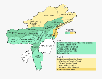
- Meghalaya, carved out of Assam as an autonomous State in 1970, became a full-fledged State in 1972.
- The creation of the new State was based on the Assam Reorganisation (Meghalaya) Act of 1969, which the Meghalaya government refused to accept.
- This was because the Act followed the recommendations of a 1951 committee to define the boundary of Meghalaya.
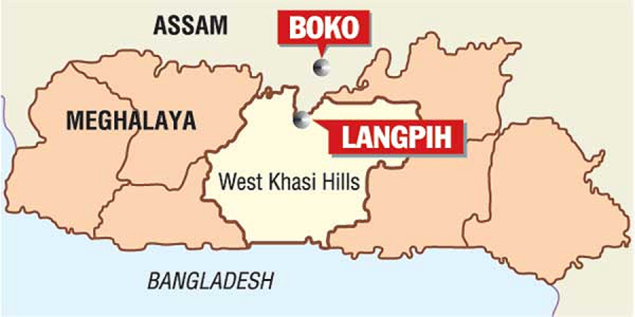
- On that panel’s recommendations, areas of the present-day East Jaintia Hills, Ri-Bhoi and West Khasi Hills districts of Meghalaya were transferred to the Karbi Anglong, Kamrup (metro) and Kamrup districts of Assam.
- Meghalaya contested these transfers after statehood, claiming that they belonged to its tribal chieftains. Assam said the Meghalaya government could neither provide documents nor archival materials to prove its claim over these areas.
- After claims and counter-claims, the dispute was narrowed down to 12 sectors on the basis of an official claim by Meghalaya in 2011.
Will the partial settlement impact border disputes elsewhere in the Northeast?
- According to the partial boundary deal, Assam will get 18.51 sq. km of the 36.79 sq. km disputed area while Meghalaya will get the remaining 18.28 sq. km.
- There is no clarity yet on the villages or uninhabited stretches that would be divided, but some political parties and community-based groups in Meghalaya are unhappy about acceding any part of the disputed areas to Assam.
- Reactions are similar in Assam, where the opposition Congress and local organisations said the agreement boiled down to how much land Assam could save from “aggressor” Meghalaya.
- But officials in Assam said it was better to let go of areas where they did not have any administrative control rather than “live with an irritant forever”.
- However, residents in the other six disputed sectors — Langpih, Borduar, Nongwah, Matamur, Deshdemoreah Block I and Block II, and Khanduli — feel the “give-and-take” template could spell disaster for them.
- The fear is more among non-tribal people who could end up living in a “tribal Meghalaya with no rights for us”.
- The apprehension is similar for residents of Assam in disputed areas along the border with other States. According to a paper tabled in the Assam Assembly in August 2014, six neighbouring States control 77,531.71 hectares of Assam land.
- Apart from Meghalaya, the other States are Arunachal Pradesh, Mizoram, Nagaland, Tripura and West Bengal.
Assam’s border dispute with Arunachal
- Assam Chief Minister disclosed that the state’s boundary dispute with Arunachal Pradesh was at 1,200 places.
- Arunachal Pradesh shares a 800-km boundary with Assam and was granted statehood by the State of Arunachal Pradesh Act, 1986 in 1987. Clashes were first reported in 1992 and since then, there have been several accusations of illegal encroachment from both sides, and intermittent clashes.
- Cases pertaining to Assam’s boundary dispute with Nagaland and Arunachal are pending in the Supreme Court.
- There was a clear delineation of the boundary when Uttarakhand and Jharkhand were created as states. However, when Mizoram, Arunachal, and Nagaland were created, it was left to certain situations and the ambiguity remained, leading to the disputes.
- Miscreants allegedly fired at Assam Forest officials in November 2021 near the Arunachal Pradesh border.
- A few days prior to which a team of Assam Forest officials were detained by allegedly illegal settlers from Arunachal Pradesh in the forest. They were later rescued by the Assam police.
- The firing coincided with the visit of the members of the border committees of Assam and Meghalaya to various areas of difference along the inter-State boundary.
- There was a mixed response from the locals the committee members met. A majority in some villages wanted to be with Meghalaya while most in some other villages wanted to be with Assam.
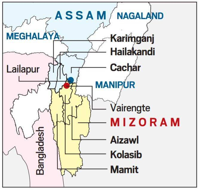
About the Assam – Mizoram Border Dispute
- Mizoram borders Assam’s Barak Valley and the boundary between present-day Assam and Mizoram is 165 km long. Both states border Bangladesh.
- The boundary issue between present-day Assam and Mizoram dates back to the colonial era when inner lines were demarcated according to the administrative needs of British Raj.
- Assam became a constituent state of India in 1950 and lost much of its territory to new states that emerged from within its borders between the early 1960s and the early 1970s.
- Mizoram was granted statehood in 1987 by the State of Mizoram Act, 1986.
- The Assam-Mizoram dispute stems from a notification of 1875 that differentiated Lushai Hills (During colonial times, Mizoram was known as Lushai Hills) from the plains of Cachar, and another of 1933 that demarcates a boundary between Lushai Hills and Manipur.
- Mizoram believes the boundary should be demarcated on the basis of the 1875 notification, which is derived from the Bengal Eastern Frontier Regulation (BEFR) Act, 1873.
- According to an agreement between the governments of Assam and Mizoram, the status quo should be maintained in no man’s land in the border area.
- In the Northeast’s complex boundary equations, clashes between Assam and Mizoram residents are less frequent than they are between other neighbouring states of Assam, like with Nagaland.
Assam-Nagaland: Nagaland shares a 500-km boundary with Assam and achieved statehood in December 1963 and was formed out of the Naga Hills district of Assam and Arunachal Pradesh (then North-East Frontier Agency). Violent clashes and armed conflicts, marked by killings, have occurred on the Assam-Nagaland border since 1965.
Battle of Pollilur
Context:
Known to be a patron of art, Tipu Sultan commissioned numerous significant paintings. Several of these have come into the limelight in recent years, fetching astronomical sums at auctions. Another work from his treasury will be auctioned at the Sotheby’s “Arts of the Islamic World & India” auction.
- Titled ‘The Battle of Pollilur’, the work described by historian William Dalrymple as “one of the great masterpieces of the period” is expected to fetch between £5,00,000 and £8,00,000.
Relevance
GS I- Modern Indian History, Important Personalities
Dimensions of the Article:
- What is the significance of the painting?
- Battle of Pollilur
- About Tipu Sultan
What is the significance of the painting?
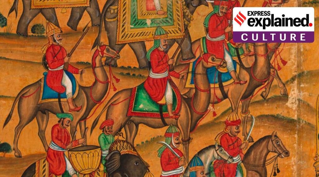
- The work was commissioned by Tipu Sultan, the last ruler of Mysore, as part of a large mural for the newly built Daria Daulat Bagh in Seringapatam in 1784.
- Only three such paintings are known to exist.
- One of them, sold at a Sotheby’s auction in 2010 for £769,250, was reportedly heavily restored, unlike the work on auction now.
- The work to come under the hammer now is part of a private collection in the UK, and has been displayed at numerous exhibitions, including a 1990 exhibition in London and a 1999 exhibition in Edinburgh.
Battle of Pollilur
- The Battle of Pollilur took place during the Second Anglo-Mysore War, which engaged English forces against the Kingdom of Mysore, which was led by Hyder Ali and his son Tipu Sultan.
- The battle took place in Pollilur, near Kanchipuram in modern-day Tamil Nadu.
- General Sir Eyre Coote led the British company forces (who is famous for his role in the decisive English victory at the Battle of Wandiwash).
- A battle between the English and the Mysorean armies took place in Pollilur in September 1780. Hyder Ali had just conquered the English at the time.
- The English, on the other hand, were victors in the battle of 1781, though it was not decisive. In fact, the English referred to it as a “dubious victory.”
- The company’s forces were split into two lines, one facing Hyder Ali’s men and the other Tipu Sultan.
- Hyder Ali’s men suffered heavy losses and were forced to flee to Kanchipuram.
- Following the battle, Coote’s forces ran out of provisions and were forced to retreat to Tripassore. This was interpreted by Hyder Ali as a retreat, but he also declared victory.
- The Treaty of Mangalore concluded the Second Anglo-Mysore War in a stalemate. Both parties promised to restore conquered areas and captives under the terms of the Treaty of Mangalore.
About Tipu Sultan
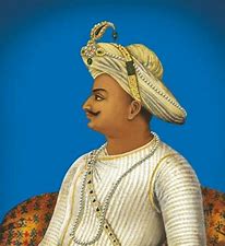
- The Kingdom of Mysore was ruled by Tipu Sultan.
- He was Haidar Ali’s son and a strong warrior, also known as the Tiger of Mysore, and was born in November 1750.
- Tipu was a great lover of democracy and a great diplomat, and he supported the French soldiers at Seringapatam in setting up a Jacobin Club in 179.
- He built his army on the European model, with Persian words of command, and he was fully aware of the naval might; he planted the Tree of Liberty at Seringapatam.
- In the Fourth Anglo-Mysore War, he was defeated and died on May 4, 1799, in Srirangapatna, Karnataka’s present-day Mandya district.
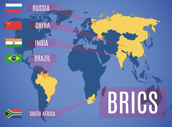
BRICS Media Forum
Context:
Recently, the BRICS countries (Brazil, Russia, India, China and South Africa) launched a three-month-long training programme for journalists. The programme was an initiative of the BRICS Media Forum.
Relevance:
GS-II: International Relations (Important International Groupings affecting India’s Interests)
Dimensions of the Article:
- What is BRICS Media Forum?
- What is BRICS?
What is BRICS Media Forum?
- The Forum was founded in 2015 by media organisations from five nations, including The Hindu (India), CMA Group (Brazil), Sputnik (Russia), Xinhua (China), and Independent Media (South Africa).
- Through exchange and pragmatic cooperation, the forum intends to establish an efficient coordination mechanism among BRICS media, accelerate innovation-driven media growth, and collect stronger impetus for BRICS countries’ development.
What is BRICS?
- BRICS is the international grouping of Brazil, Russia, India, China and South Africa.
- This was set up as a move towards greater multipolarity; hence the spread across three continents and both hemispheres.
- In terms of GDP, China occupies the second position; India the fifth; Brazil the ninth; Russia the 11th; and South Africa the 35th.
- In terms of growth rates, China grew at 6%; India at 4.5%, Russia 1.7%, Brazil 1.2% and South Africa 0.1%.
- BRICS does not exist in form of organization, but it is an annual summit between the supreme leaders of five nations.
- The Chairmanship of the forum is rotated annually among the members, in accordance with the acronym B-R-I-C-S.
- The BRICS seeks to deepen, broaden and intensify cooperation within the grouping and among the individual countries for more sustainable, equitable and mutually beneficial development.
- BRICS takes into consideration each member’s growth, development and poverty objectives to ensure relations are built on the respective country’s economic strengths and to avoid competition where possible.
- BRICS is emerging as a new and promising political-diplomatic entity with diverse objectives, far beyond the original objective of reforming global financial institutions.